Radio Eyes Help

This tool helps you create a table of minimum elevations for each point on your horizon. This table is saved as a horizon file which can be loaded to customize the horizon line displayed on the sky map for your location.
The horizon file format is very simple:
# File format :
# Azimuth(integer) Altitude
#
# Be sure to begin at the North horizon (azimuth 0)
# Intermediate missing values are interpolated
0 39.9
10 39.9
15 39.9
20 25.0
(and so forth)
With a list of minimum horizon elevations you could produce this file in an ordinary text editor such as notepad. Lines beginning with # symbols are ignored by the program when the horizon file is read. Each line begins with an integer azimuth value followed by a value of elevation.
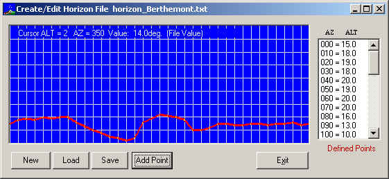
The Horizon File editor provides a graphical and manual means of producing these horizon files. The graphical interface is an ALTAZ chart with zero degrees at the bottom, 90 degrees elevation at the top, 0 degrees azimuth at the left and 359 degrees azimuth at the right. Moving the mouse over the chart produces a readout of the pointed to values in an area at the top of the chart. Not every azimuth point needs to be defined. If a point is not defined, its value is indicated as interpolated.
Begin by either by pressing the Load button or the New button. New charts are initialized with defined points at 10 degree azimuth intervals, all set to 0 (zero) azimuth.
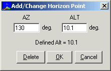
The easiest way to edit an already defined point is to click on the desired line of the list of points at the right of the window. The following dialog box will appear:

Modify the ALT value as desired. You can also use this method to select points for deletion or to add a new point by specifying a different azimuth. A second method of selecting points uses the graph. Move the mouse to the desired ALTAZ on the graph and RIGHT click, then select Place Horizon Point Here.
The Add Point button also brings up the Add/Change Horizon Point dialog box initialized to zeros.
After creating and/or editing your horizon file use the Save button to make the work permanent. You must set the appropriate options under View/Horizon of the main sky map in order to make your horizon file visible on the sky map.